Application of GPS Centralized Differential Technology in Urban Vehicle Intelligent Traffic Management
In foreign countries, vehicle-mounted GPS global positioning system is gradually becoming a must-have configuration for medium and high-end vehicles. In the United States, Rockwell has developed an advanced turn-by-turn navigation and information system. The system includes a small color display screen, direction sensor, and GPS receiver. The system has the most effective road selection function, turn-by-turn turning function, and vehicle accuracy. Multiple functions such as positioning. In Japan and European countries, GPS vehicle automatic navigation systems and GPS-based intelligent geographic information management systems have been installed in medium and high-end vehicles.
With the continuous expansion of the scale of urban construction in China and the increasing number of urban vehicles, especially the traffic management, traffic services and traffic safety of vehicles are becoming more and more important. Therefore, the vehicle-mounted GPS system has been more and more widely used.
Intelligent transportation system-ITS (interligent transport system) and radio communication system are combined together, and the vehicle and the command center can communicate through duplex to form a positioning navigation and traffic management system, which not only enables the vehicle to have the ability of positioning navigation And, it can dispatch, manage and provide various services to vehicles. It mainly completes vehicle identification and positioning, automatic navigation, traffic monitoring, communication and information processing technology.
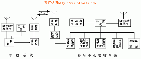
The system structure of ITS mainly includes three parts: vehicle-mounted system, communication system and ground monitoring center management system
1. Vehicle-mounted system It consists of vehicle-mounted positioning unit, location information sending and receiving unit, display unit and vehicle-mounted computer.
The main functions of car GPS:
1) Vehicle-mounted positioning unit The GPS receiver receives the positioning information from the satellite in real time, such as giving the real-time position and speed of the motor vehicle.
2) Receive and send function of positioning information
The GPS receiver locates the information in real time and sends the positioning information to the monitoring center, and at the same time receives the dispatch instruction sent by the monitoring center.
3) Data display function Display the real-time position of own vehicle and the dispatch command sent by the ground monitoring and command center.
4) Alarm function Once an emergency occurs, the alarm device is activated, and the monitoring center immediately displays information such as vehicle conditions, accident location and time.
2. Communication system The communication system uses the duplex communication unit for the motor vehicle and ground monitoring center control management system to send the vehicle's position, status, service request and other information to the center management system or receive information and commands from the control center.
3. The ground monitoring center management system is composed of a central control management station, a computer, a dispatch management system, a database, a communication routing management system, and a large-screen display.
The computer has a digital map, an advanced AVLN system and is equipped with address matching, map matching, best path calculation and driving guidance.
The large-screen display can display information such as the location of the vehicle on a digital map.
2 Principle of centralized differential technology
In general differential GPS technology, a GPS receiver needs to be installed in each car, and the correction number is received, which will cause the disadvantages of the complex structure of the vehicle-mounted system and the slow working speed. Therefore, centralized differential technology can be used in practical applications.
The centralized differential technology includes two parts, the vehicle-mounted part and the control center management system. The vehicle-mounted part is equipped with a GPS receiver and a communication station. It only receives GPS signals without considering the reception of differential signals, and sends GPS positioning signals to the ground monitoring through the communication station. In the center, the monitoring center concentrates on differential processing, recording, storage, and data.
The ground monitoring center is set at the position of the reference station, and the coordinates are accurately known. A GPS receiver is installed on the reference point, and a communication station, computer, electronic map, and display are also installed. When working, the GPS receiver on each vehicle sends its position, time and vehicle number to the monitoring center. The monitoring center GPS receiver compares the measured three-dimensional position with the known coordinates of the station to find Difference correction number. And send back to the vehicle, correct the position of the vehicle, calculate the real-time position of the vehicle, and display it on the screen after coordinate transformation.
The system works as shown

2. Measurement method: 
Pseudorange differential technology is currently the most widely used differential technology. Almost all commercial differential GPS receivers use this technology, as does RTCM-104 recommended by the International Maritime Radio Commission. Therefore, from the perspective of versatility and practicality of the system, the pseudorange differential technology is adopted in the centralized differential positioning system.
Suppose that the precise coordinates of the reference station (control center) are (X0, Y0, Z0), and the geocentric coordinates of the i-th satellite at a certain time calculated from ephemeris data are (Xi, Yi, Zi), then this time The distance from the satellite to the base station is 
3 Error analysis:
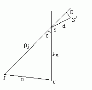
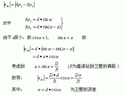
Let J be the position of the base station, U be the position of the user's vehicle-mounted equipment, the distance between the reference station and the user station is n, the pseudo distance from the base station to the satellite is Ïj, and the pseudo distance from the user to the satellite is Ïu. Suppose the slope distance between the actual position of the satellite and the position where the GPS signal is propagated is d, and the pseudo-range measurement errors of the reference station and the user station are δÏj and δÏu, respectively. It can be seen from the figure that δÏj ≠δÏu. There is obviously a residual error that cannot be calibrated by using the pseudo-station differential error δÏj of the reference station to correct the measured value of the user's on-board equipment. The error value is:

It can be seen that this method can offset the common error between the vehicle and the reference station.
If the position error of the satellite is σ = 1000m, the true distance between the reference station and the satellite is R = 20000Km. As the distance between the vehicle and the ground monitoring and command center changes, the measurement error is as follows: 
As can be seen from the table above, for urban traffic vehicle management, as long as the distance between the vehicle and the ground monitoring and command center does not exceed the range, the measurement accuracy is high enough.
From the practical application point of view, the centralized differential technology has the characteristics of simple structure of the vehicle-mounted equipment and small measurement error. At the same time, the data communication can use the communication equipment of the original vehicle, as long as the communication conversion interface is added. Therefore, it has a better practical application effect.
Z10 Bone Conduction Earphone,Wireless Bluetooth Air Conduction Headphone,Wireless Headset Bone Conduction,Wireless Bluetooth Headphone
Shenzhen Lonfine Innovation Technology Co., Ltd , https://www.lonfinesmart.com
