
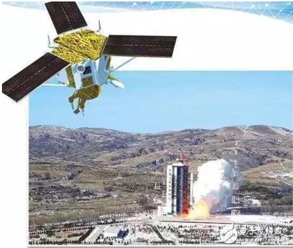
At 11:23 on December 28, 2016, China successfully launched the Gaojing No. 1 commercial remote sensing satellite at the Taiyuan Satellite Launch Center with the Long March II carrier rocket. Gaojing No.1 is the first star of China Aerospace Science and Technology Corporation's commercial remote sensing satellite system. It is developed by China Aerospace Science and Technology Corporation Wuyuan Aerospace Dongfanghong Satellite Co., Ltd., and will be limited by China Aerospace Science and Technology Corporation. The company is responsible for commercial operations.
The Gaojing-1 satellite consists of two optical satellites with a 0.5-meter splitting rate. It features professional-grade image quality, high agility maneuverability, rich imaging modes and highly integrated electronic systems. After the application in orbit, it will break the current situation that China's 0.5-meter commercial remote sensing data is monopolized by foreign countries, and it also marks the official entry of domestic commercial remote sensing data into the international popular list.
On January 9, 2018, Gaojing 3 and 4 were successfully launched again. Let's take a look at the specific information.
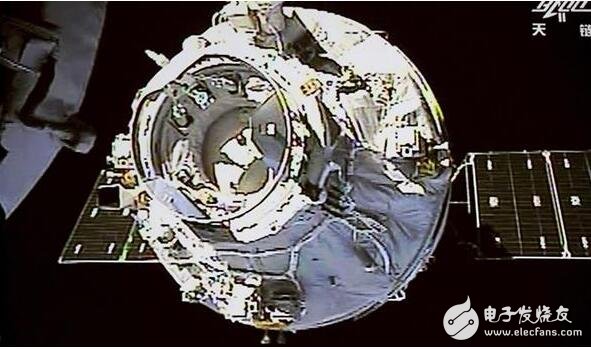
Gaojing No. 1 was successfully launchedAt 11:24 on January 9, China used the Long March II carrier rocket at the Taiyuan Satellite Launch Center to launch the Gaojing No.1 03 and 04 stars, and the satellite successfully entered the planned orbit. This is also the first of the Long March series of launch vehicles. 261 launches.
After Beijing time yesterday morning (January 8, 9:00) US SpaceX world premiere of the 2018 space launch, just one day later, China also launched a launch vehicle, becoming the world's second.
At 11:24 on January 9th, China successfully launched Gaojing No.1 03 and 04 stars in the Taiyuan Satellite Launch Center with the Long March II carrier rocket. After the satellite entered the scheduled orbit, it was operated with the Gaojing No. 01 and 02 star networks operating in orbit, marking the official completion of China's first 0.5-meter high-resolution commercial remote sensing satellite constellation.
The Gaojing series satellites were developed by the China Academy of Aerospace Science and Technology Group Co., Ltd., and were jointly commercialized by China 4D Surveying and Mapping Technology Co., Ltd. This is the 261th launch of the Long March series of launch vehicles.
Domestic civilian remote sensing satellite "the strongest" constellation
The reporter learned from China 4D Surveying and Mapping Technology Co., Ltd. that compared with Gaojing No.1 01, 02 stars, 03 and 04 stars, the image quality optimization design of the satellite and the ground was carried out, and the geometric quality of the image was greatly improved. The four-star network has upgraded its service capabilities and is the "strongest" in the domestic civil remote sensing satellite constellation.
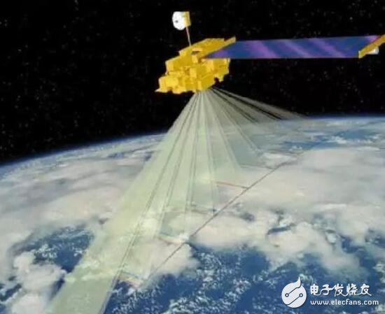
According to reports, the Gaojing No. 1 constellation has the ability to revisit once a day in any location in the world. Through flexible working modes and integrated data acquisition and transmission capabilities, it can realize 10 minutes of imaging per track and quickly transmit it. The 10,000 square kilometer image provides high-level, all-weather Earth observation and remote sensing data services and application system solution services to users around the world.
Domestic and foreign markets are emerging
In December 2016, Gaojing No. 1 debut star 01, 02 stars successfully launched, and in April 2017 officially began to provide commercial remote sensing services. As of December 2017, it has completed more than 225,000 scenes of global imaging, covering an area of ​​24.56 million square kilometers.
As a new star in the field of remote sensing, Gaojing No.1 contributed to the fields of surveying and mapping, land and resources survey, urban construction, agriculture, forestry and water conservancy, geology and mineral resources, environmental monitoring, national defense security and emergency disaster reduction: participated in the National Basic Geographic Information Center in 2017. The aerospace remote sensing image acquisition project, the 2017 national land use change survey monitoring and verification project, provide imaging basis for government decision-making; carry out large-scale satellite remote sensing data collection and security in Shandong and Jiangsu, and implement “multi-regulation†for provincial governments. Management contribution; providing post-earthquake data of the Sichuan Aba earthquake and the Xinjiang Kash earthquake, providing emergency data support for earthquake relief; responding to the government's call to provide post-earthquake data assistance for the earthquakes in Mexico and Iraq.
Not only in the country, but also in the international market, Gaojing No.1 has a small test. In April 2017, China signed a contract with Norwegian Kangshibo to establish an Arctic station service contract, which greatly improved the global data reception and comprehensive data acquisition capability of Gaojing-1, and officially launched cooperation between domestic commercial remote sensing satellite operators and ground stations in the Arctic high latitudes. Up to now, Gaojing No. 1 has signed cooperation agreements with more than 20 foreign sales agents, covering a total of 17 countries on five continents.
The significance of the successful launch of Gaojing No.1 03 and 04It marks the first phase of China's first 0.5-meter high-resolution commercial remote sensing satellite constellation. In 2018, China's space launch has achieved a good start.
The Gaojing commercial remote sensing satellite system was developed by the five institutes affiliated to China Aerospace Science and Technology Corporation, and was commercialized by China 4D Surveying and Mapping Technology Co., Ltd., a professional company affiliated to China Aerospace Science and Technology Corporation.
After the first batch of four 0.5-meter high-resolution optical remote sensing satellites of the Gaojing commercial remote sensing satellite system, it will realize 10 minutes of imaging per track and quickly transmit it. It can collect 3 million square kilometers of images per day, providing high prices for users around the world. Remote sensing data services and application system solution services for all-weather Earth observation. Previously, on December 28, 2016, the Long March II carrier rocket successfully launched Gaojing No. 01 and 02 stars. In April 2017, Gaojing No.1 01 and 02 stars officially provided commercial remote sensing services. As of December 2017, Gaojing No. 1 completed more than 225,000 scenes of global imaging, covering an area of ​​24.56 million square kilometers. The service targets include surveying and mapping, land and resources survey, urban construction, agriculture, forestry and water conservancy, geology and minerals and many other industries.
It is reported that Gaojing No. 1 satellite provides strong support for the national steel industry's de-capacity effect monitoring task, and provides satellite remote sensing data for the third national agricultural census. After signing the Arctic Station Service Contract with Norwegian company, the cooperation between domestic commercial remote sensing satellite operators and ground stations in the Arctic high latitudes was officially launched.
China 4D has established an international satellite data distribution channel and has signed cooperation agreements with more than 20 foreign sales agents. The cooperation covers 17 countries on five continents.
It is understood that Gaojing commercial remote sensing satellite system has great application potential in the Internet, smart city, financial insurance and other industries. Through the integration with mobile Internet, navigation and positioning, intelligent terminals and virtual reality technologies, it will strongly promote the integration of remote sensing technology in China. Government management, corporate production and public life.
Fume Vape,Fume Extra Vape,Fume Infinity Vape,Fume Ultra Vape Pod
Nanning Nuoxin Technology Co., LTD , https://www.nx-vapes.com